Where are the animals?
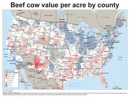
A county-by-county details of where the U.S. poultry, beef cow, dairy cow and hog inventories can be found.
October 6, 2014
1 Min Read

Mapping Livestock Data
The following maps provide county-by-county details of where the U.S. poultry, beef cow, dairy cow and hog inventories can be found. To create the poultry map, the inventories for broilers and other meat birds, layers and turkeys were aggregated by county for the contiguous 48 states. Data were compiled from the U.S. Department of Agriculture's National Agricultural Statistics Service and the 2007 Census of Agriculture.
You can download an Excel spreadsheet of the census data used to create the maps by clicking HERE.
Subscribe to Our Newsletters
Feedstuffs is the news source for animal agriculture
You May Also Like


.png?width=300&auto=webp&quality=80&disable=upscale)
