Precipitation to eventually alleviate Mississippi River woes
Mississippi River levels break records as drought persists.

The water-level gauge on the Mississippi River at Memphis, Tenn. captured an official record low of −11.52 feet on October 11, surpassing the previous record low of −10.81 feet that occurred in October 2022, USDA’s weekly “Grain Transportation Report” noted. On October 17, the Memphis gauge read an unofficial record low of −11.98 feet that the U.S. Army Corps of Engineers has not yet verified.
USDA reported that records were also broken on the Ohio River at Cairo, Illi., where the water-level gauge read 4.5 feet, the lowest since 1901, and on the Missouri River at New Madrid, Mo., where the reading was −6 feet.
Draft and tow-size restrictions are in place along the entire river system, and despite some recent rain, more rain will be needed to raise water levels enough to improve navigation conditions, USDA said.
“Water levels are projected to rise by late October and early November, but navigation conditions are not expected to improve before late December or early January,” the report noted.
Despite the navigation issues, last week, the St. Louis spot freight rate fell for the third week in a row to $23.06 per ton—down 68% from the same week last year—and 496,000 tons of grain moved through Mississippi River locks to the U.S. Gulf.
USDA Chief Meteorologist Brad Rippey said that work done by the U.S. Army Corps of Engineers over the last year has prevented the record-low levels from affecting river traffic like last year. However, river traffic has declined due to post-harvest decisions by farmers.
“Folks are hanging onto the grains and oilseeds a bit longer, and at least while there is storage available, a lot of those are not being shipped at this time,” Rippey said.
A fairly soft export has also contributed to the decline in barge traffic, he added.
Even so, barges that are running have had to reduce their loads by about one-third to keep from scraping bottom.
Good news on the horizon
The picture remains grim for much of the South as the latest U.S. Drought Monitor reported widespread degradations last week across the Tennessee Valley, central Mississippi Valley and northern parts of the Southern Plains.
The good news, however, is that a front extending from the Upper Mississippi Valley to the Southern High Plains will move eastward to the Lower Great Lakes/Mid-Atlantic to the Central Gulf Coast over the next week. The system, the Drought Monitor said, will produce rain over parts of the Upper/Middle Mississippi Valley on Wednesday evening, moving into the Great Lakes/Ohio Valley by Thursday and continuing eastward into Friday.
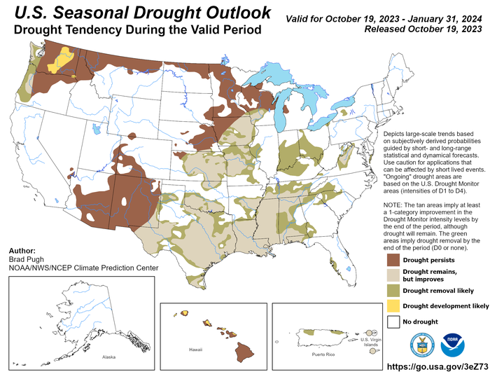
The National Oceanic and Atmospheric Administration (NOAA) released its U.S. Winter Outlook last week, which also provided some positive news for the South, although longer term.
“An enhanced southern jet stream and associated moisture often present during strong El Nino events supports high odds for above-average precipitation for the Gulf Coast, lower Mississippi Valley and Southeast states this winter,” said Jon Gottschalck, chief of the operational prediction branch of the National Weather Service’s Climate Prediction Center.
Even as widespread extreme to exceptional drought will continue to persist across much of the South, and portions of the central U.S., NOAA said drought conditions are expected to improve across the Southeast, the Gulf Coast (including the lower Mississippi Valley), and Texas due to the expected wetter-than-average forecast.

About the Author(s)
You May Also Like


