La Nina watch removed as conditions neutralize
Chance of La Nina now only about 55-60% during fall and winter of 2016-17.

A newly released National Weather Service Climate Prediction Center (CPC) report says La Niña weather conditions are now only slightly favored to develop during August to October 2016. The report provided an update on the current state of ENSO (El Nino/La Nina/Neutral), revealing that there is only about a 55-60% chance of La Niña during the fall and winter of 2016-17.
La Niña is characterized by unusually low ocean temperatures in the central and eastern equatorial Pacific. It puts emphasis on the northern jet stream while weakening the jet stream in the south, keeping moisture in the northern half.

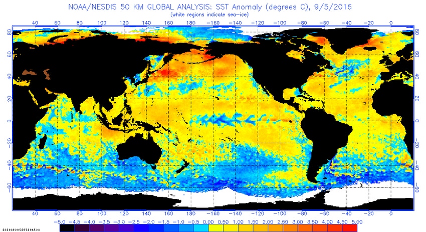
Sea surface temperature patterns in Septemnber 2016. Redder colors indicate where average monthly sea surface temperatures were warmer than the 1981-2010 average, while blue colors indicate where sea surface temperatures were cooler than average. Source: NOAA
In June, the National Oceanic & Atmospheric Administration (NOAA) said the chances of La Niña occurring this fall were 75%, but in July the projection fell to around 55-60%, where it remains today.
“Sea surface temperatures were cooling, but the pace of cooling has slowed. ENSO conditions are likely to remain neutral through fall,” NOAA noted. As such, forecasters have dropped the La Niña watch.
CPC said most multi-model averages indicate a borderline or a weak La Niña starting during the Northern Hemisphere fall and persisting through this winter.
What happened?
According to CPC contractor Dr. Emily Becker, sea surface temperature anomalies in the Niño3.4 region have, over the last few months, become more negative, which was expected. Currently, the sea surface temperature in the Nino3.4 region is about -0.5° below the long-term average, the La Niña threshold.
Becker said a second step in the La Niña conditions process is deciding whether the sea surface temperature will stay below the threshold for the next several overlapping seasons. “For now, the answer to this question is ‘no’,” she added.
In fact, Becker said the dynamical climate models are predicting that September’s Niño3.4 index will be the low point and that sea surface temperatures will recover to near average over the next few months.
“There is still a range of forecasts, but all eight of the North American Multi-Model Ensemble models expect the negative anomalies to weaken toward zero,” she said.
Becker did add, however, that a La Niña could certainly still develop.
“While a strong La Niña developed immediately after the 1997-98 El Niño, there was nearly a year of slightly below-average temperatures following the 1982-83 El Niño before a moderate La Niña eventually developed in October of 1984 — further evidence that there are many pathways that the climate system can follow after a large El Niño event,” she said.
For now, though, Becker said most signs point toward a stronger chance of remaining in neutral conditions for the time being.
About the Author(s)
You May Also Like


