La Niña to bring cool North, warm South conditions
Nearly 47% of the U.S. is experiencing some form of drought, highest level since September 2013.

The National Oceanic and Atmospheric Administration (NOAA) recently released its winter forecast for the U.S., revealing odds favor warmer, drier conditions across the South, and cooler, wetter conditions in the North, the result of an ongoing La Niña. Forecasters at NOAA’s Climate Prediction Center — a division of the National Weather Service — are also closely monitoring persistent drought during the winter months ahead.
Currently, large areas of drought extend over the western half of the U.S., with parts of the Northeast also experiencing drought and near-record low stream flows.
The most recent U.S. Drought Monitor showed nearly 47% of the U.S. is experiencing some form of drought and nearly 65% of the country is experiencing dryness. The U.S. Department of Agriculture said the current levels are the highest seen since September 2013, when the U.S. was coming out of one of the worst droughts in U.S. history.
With a La Niña climate pattern in place, NOAA said southern parts of the U.S. may experience expanded and intensifying drought during the winter months ahead.
“With La Niña well established and expected to persist through the upcoming 2020 winter season, we anticipate the typical, cooler, wetter North, and warmer, drier South, as the most likely outcome of winter weather that the U.S. will experience this year,” said Mike Halpert, deputy director of NOAA’s Climate Prediction Center.
Temperature
According to the outlook, the greatest chances for warmer-than-normal conditions extend across the Southern tier of the U.S. from the Southwest, across the Gulf states and into the Southeast. More modest probabilities for warmer temperatures are forecast in the southern parts of the west coast, and from the Mid-Atlantic into the Northeast. Above-average temperatures are also favored for Hawaii and western and northern Alaska.
Below-normal temperatures are favored in southern Alaska and from the northern Pacific Northwest into the Northern Plains, with equal chances for below-, near- or above-average temperatures in the remaining regions.
Precipitation
NOAA predicts wetter-than-average conditions are most likely across the northern tier of the U.S., extending from the Pacific Northwest, across the Northern Plains, Great Lakes and into the Ohio Valley, as well as Hawaii and northern Alaska. The greatest chances for drier-than-average conditions are predicted in the Southwest, across Texas along the Gulf Coast, and in Florida. More modest chances for drier conditions are forecast in southern Alaska, and from California across the Rockies, Central Plains and into the Southeast. The remainder of the U.S., including the Mid-Atlantic and Northeast, falls into the category of equal chances for below-, near-, or above-average precipitation.
Drought
NOAA said widespread, ongoing drought is currently in place across the western half of the continental U.S. as a result of the weak Southwest summer monsoon season and near-record-high temperatures. Drought is also present in parts of the Northeast, Ohio Valley, Hawaii and Alaska. The ongoing La Nina is expected to expand and intensify drought across the southern and central Plains, eastern Gulf Coast, and in California during the months ahead. Drought conditions are expected to improve in the northern Rockies, Northwest, New England, Alaska and Hawaii over the coming months.
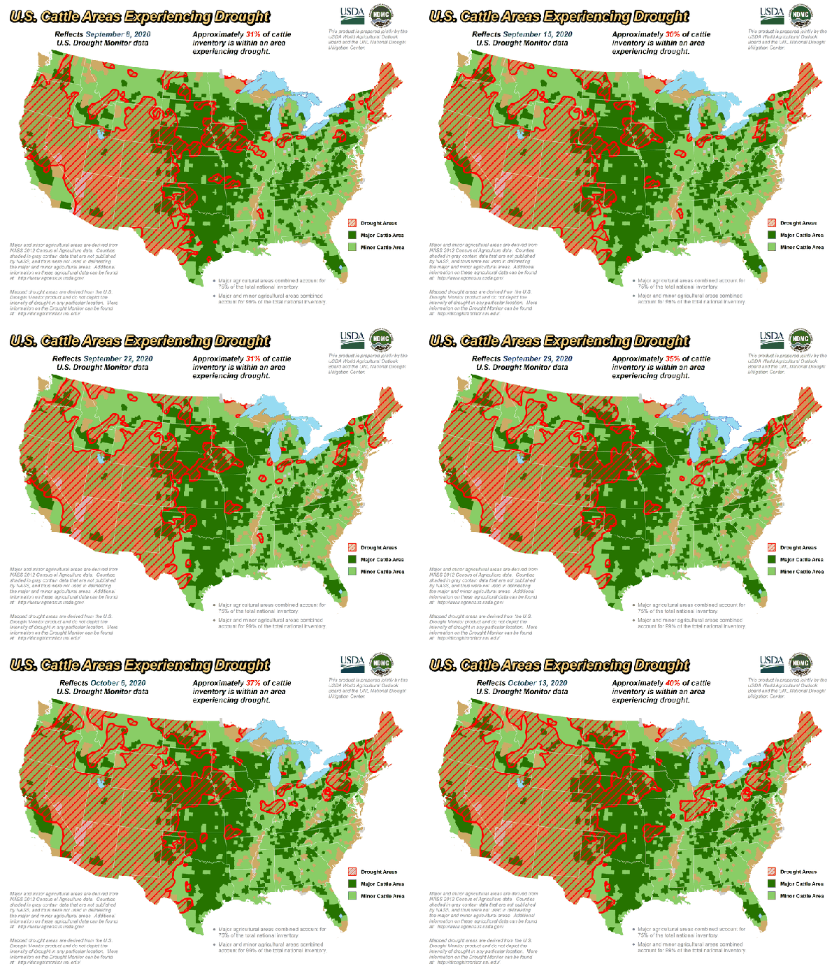
According to the USDA, as of Oct. 13, 40% of the U.S. cattle inventory is within an area experiencing drought, up from 31% on Sept. 8. Approximately 51% of alfalfa hay acreage area is in drought, and 31% of hay acreage is in drought. About 46% of U.S. winter wheat production area is experiencing some form of drought.

About the Author(s)
You May Also Like


